Why the Pinehaven flood maps must be included in the current consultation
Greater Wellington Regional Council (GWRC) and Wellington Water Limited (WWL) are currently consulting the public on Upper Hutt Flood Hazard Modelling.
Consultation opened Monday 3rd November and closes Friday 12 December 2025.
The flawed and outdated Pinehaven and Silverstream flood maps (2010) have been left out of the consultation. A fair and transparent consultation must include all Upper Hutt flood maps, not exclude the ones with the most serious unresolved issues.
Here are some suggested points to help you write your own submission:
- Please include the Pinehaven Stream flood maps in the current Upper Hutt flood mapping consultation.
- The existing Pinehaven and Silverstream flood maps are based on old, flawed and outdated modelling (2010).
- The Pinehaven and Silverstream flood maps have never been properly updated.
- The Pinehaven and Silverstream flood maps do not match real flood events.
- The Pinehaven and Silverstream flood maps are not reliable.
- The Pinehaven and Silverstream flood maps significantly overstate flood extents, falsely showing many properties flooded that are not actually in a flood zone.
- Leaving out the Pinehaven and Silverstream flood maps undermines public trust.
- Pinehaven and Silverstream residents deserve accurate, up-to-date maps and they should not be excluded from a city-wide flood map review.
Click the link here and be sure to make your submission by Friday 12 December 2025.
Reasons the Pinehaven Flood Maps Must Be Included in the Current Consultation:

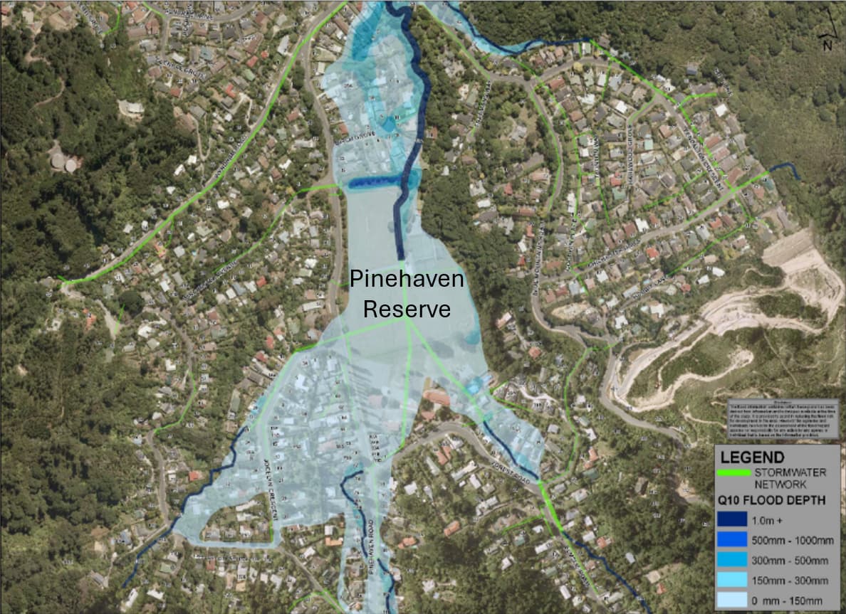
In Council’s 10-year flood map, Pinehaven Reserve and many homes are totally flooded (Source: GWRC, 2010) 
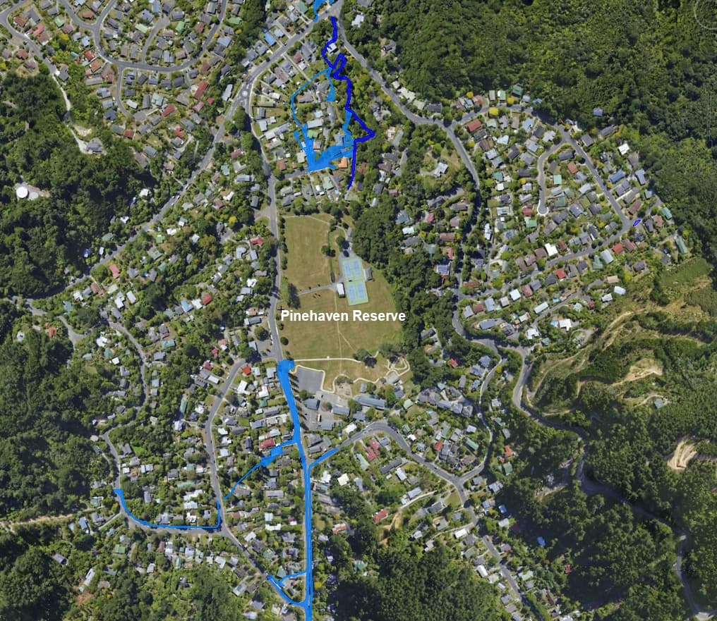
In the 25-year flood 8 December 2019, the Reserve and 99% of Pinehaven homes were not flooded. 
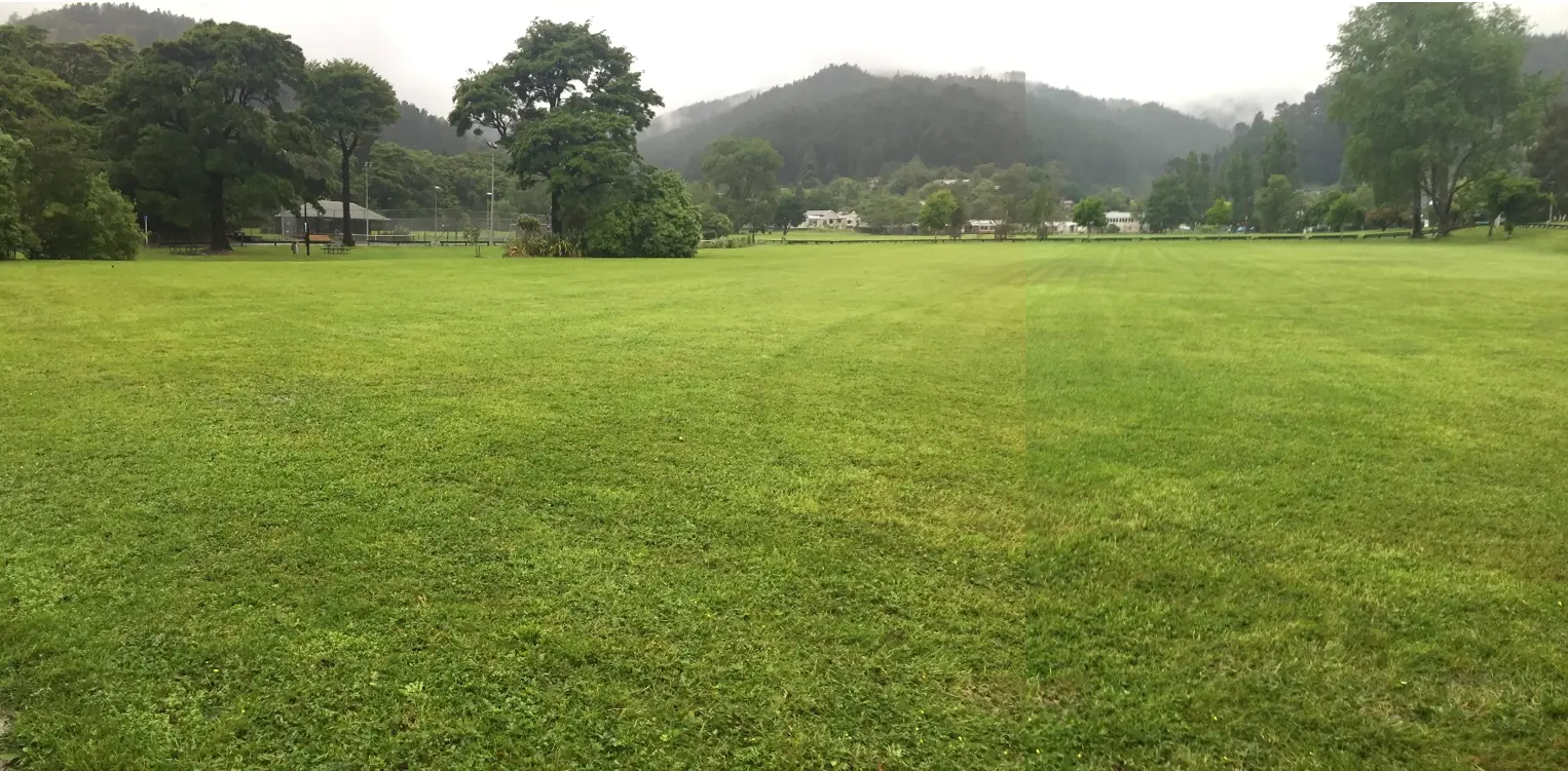
No flooding in Pinehaven Reserve at the peak of the 25-year flood on 8 December 2019.
The Pinehaven flood maps are based on a flawed and outdated model that has never been properly checked.
The current Pinehaven flood maps were built from a flood model that:
- was calibrated to only one flood that occurred on 23 July 2009,
- was based on no local rainfall data because Council removed the Pinehaven rain gauge from the catchment for 2 years while they carried out the Pinehaven flood study (2008 – 2010),
- used the wrong peak water level – the stream gauge recorded 1.6m peak water level on 23 July 2009 but Council used a peak water level in their model of only 1.2m,
- was based on a flood that Council staff or consultants never observed – they didn’t visit the catchment until the day after the flood on 23 July 2009,
- is for a flood on 23 July 2009 for which Council never published any maps of observed flood extents nor any photographs of the flood,
- wasn’t ‘ground-truthed’ against flood observations on 23 July 2009 by the public because at the ‘drop-in’ session in Pinehaven on 12 September 2009 the Council never published or displayed it’s modelled flood extents for 23 July 2009,
- was never validated against later floods, and
- was never updated despite the consultants and the Beca auditor recommending that it should be.
Because of this, the maps are not reliable and should not be left out of a region-wide flood mapping update.
The Pinehaven and Silverstream flood maps massively overstate real flood extents, and residents have the evidence.
Residents documented:
- 27 eyewitness accounts of the 1976 flood,
- extensive surveys, eyewitness accounts and over 500 photographs of the flood on 8 December 2019,
- hydrologist and flood-engineer reports for the 1976, 2009 and 2019 floods.
All show that the official maps greatly exaggerate flooding, in many places by as much as three to six times the real flood volumes.
The exaggerated flood extents can be seen when comparing Council’s 10-year flood map with actual flood extents in a real 25-year flood on 8 December 2019:
If the consultation excludes Pinehaven, these false maps will continue to:
- mislabel safe properties as flood-prone,
- lower property values,
- trigger unnecessary building restrictions,
- and distort insurance risk assessments.
Residents deserve the chance to have accurate maps included in the review.
The Pinehaven model got major floods wrong: 1976, 2009 and 2019.
Independent experts now conclude:
- The 1976 flood was not a 100-year event, but at least a 1,000-year event.
- The 2009 flood was not a 5–10-year event, but a 38–40-year event.
- Council’s 25-year flood map does not match the 2019 flood (a 25-year event) – the model over-predicts flooding by a very wide margin.
A flood model that gets all three of its key events wrong cannot be left out of a city-wide flood-map update.
The model hides the flood impact of the proposed Guildford Timber Company (GTC) development on the Pinehaven hills.
The modelling error that used urban-style rainfall losses for the forested hills means the “current” model behaves as if the hills are already developed.
This:
- inflates today’s flooding, and
- hides the extra runoff that real development on the hills will generate.
In short: the baseline is wrong and future development effects will be masked.
Pinehaven maps must be reopened now, while the city is updating all the other maps, so that extra runoff from any new subdivisions on the Pinehaven hills will not be concealed by a faulty and inflated baseline flood model.
Leaving Pinehaven out undermines public trust and risks $60 million on overpriced and over-engineered flood protection works for a 25-year flood.
Council’s own documents show the Pinehaven flood maps were used to justify:
- the $8 million Pinehaven Road culvert which was unnecessary – the previous culvert coped with the 25-year peak flow on 8 December 2019,
- the $60 million streamworks – grossly over-engineered for a 25-year flood,
- land rezoning decisions, and
- urban and residential development approvals.
If Pinehaven is excluded from the consultation:
- the public cannot challenge outdated or incorrect maps,
- planning decisions will continue using faulty information,
- Pinehaven will continue to get no flood protection from the $60 million streamworks,
- and ratepayers may continue paying for oversized or unnecessary infrastructure.
A fair and transparent consultation must include all Upper Hutt catchments, not exclude Pinehaven Stream catchment – the one with the most serious unresolved flood mapping issues.